 Maps are more than geographical tools; they are storytellers that convey complex narratives of culture, identity, and resistance. Traditionally, maps created by Europeans often erased the cultural landscapes and histories of indigenous communities. African perspectives challenge these traditional representations. By emphasizing Indigenous knowledge and experiences, these perspectives reveal how maps serve as a tool for reclaiming historical and cultural narratives. They tell living stories, connecting past struggles to present identities while preserving the richness of African heritage. Maps become living documents, preserving the interconnectedness of people, land, and history while affirming African cultural identities. They do not merely depict physical terrain but also tell stories of community and resistance. This reframing of mapping practices invites us to engage with history in a way that honors the voices of those often silenced in traditional narratives. Through this lens, maps are transformed into vehicles for historical reclamation and empowerment.
This unit invites students to explore the intersection of geography, culture, and storytelling as tools for understanding history. Beginning with the basics of maps, students learn how these tools connect stories to places and people, highlighting the diverse cultural and historical landscapes of Africa. Through the study of Nigeria’s colonial history, learners analyze the impacts of European imperialism and the resilience of indigenous communities in maintaining cultural identity. Students engage in oral traditions and counter-mapping, to challenge dominant narratives and reclaim historical agency. By reflecting on the biases embedded in colonial perspectives, they gain insight into the lasting consequences of imperialism on societies like Nigeria. Activities include analyzing primary sources, creating maps that center African perspectives, and discussing how diverse narratives reshape historical understanding. Students also explore how indigenous knowledge systems served as forms of resistance to colonial oppression. By critically examining these themes, learners develop an appreciation for multiple historical perspectives and the importance of elevating marginalized voices. This unit lays the groundwork for understanding how history is not only recorded but also reclaimed through purposeful and inclusive storytelling.
NJ Student Learning Standards (NJSLS) and Common Core Standards
Social Studies Standards (6-8)
- 6.2.8.B.4.a: Assess how geography, climate, and natural resources presented challenges and opportunities for trade, expansion, and the rise of cultural centers and kingdoms.
- 6.2.8.B.4.b: Analyze how geography influenced the development of political, economic, and cultural centers and explain the role of natural resources in shaping imperialism.
- 6.2.8.D.4.a: Explain how African societies responded to European imperialism.
- 6.2.8.D.4.b: Evaluate how European imperialism affected indigenous populations.


![King Koko [King Frederick William Koko Mingi VIII] of Nembe in His War Canoe to resist European seizure of African resources. King Koko [King Frederick William Koko Mingi VIII] of Nembe in His War Canoe to resist European seizure of African resources. King Koko [King Frederick William Koko Mingi VIII] of Nembe in His War Canoe to resist European seizure of African resources. King Koko [King Frederick William Koko Mingi VIII] of Nembe in His War Canoe to resist European seizure of African resources. King Koko [King Frederick William Koko Mingi VIII] of Nembe in His War Canoe to resist European seizure of African resources. King Koko [King Frederick William Koko Mingi VIII] of Nembe in His War Canoe to resist European seizure of African resources. King Koko [King Frederick William Koko Mingi VIII] of Nembe in His War Canoe to resist European seizure of African resources. King Koko [King Frederick William Koko Mingi VIII] of Nembe in His War Canoe to resist European seizure of African resources. King Koko [King Frederick William Koko Mingi VIII] of Nembe in His War Canoe to resist European seizure of African resources. King Koko [King Frederick William Koko Mingi VIII] of Nembe in His War Canoe to resist European seizure of African resources. King Koko [King Frederick William Koko Mingi VIII] of Nembe in His War Canoe to resist European seizure of African resources. King Koko [King Frederick William Koko Mingi VIII] of Nembe in His War Canoe to resist European seizure of African resources.](https://www.njamistad.com/wp-content/uploads/2025/01/AM-01-03_King_Koko_in_His_War_Canoe-150x150.jpg)

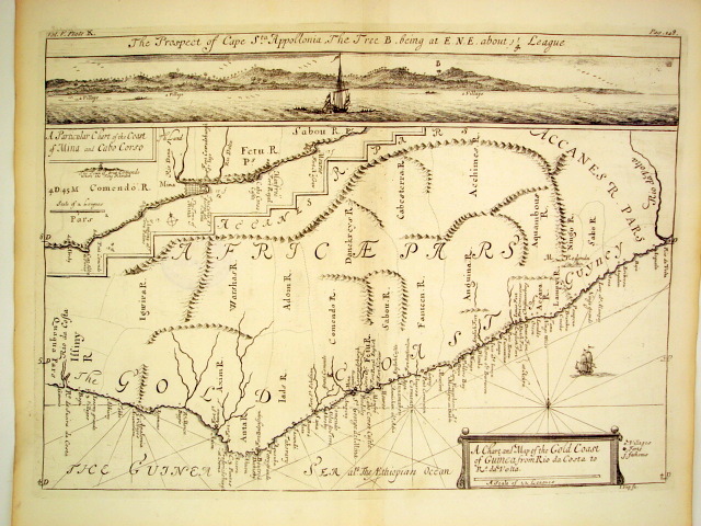
![A Chart and Map of the Gold Coast of Guinea from Rio da Costa to Rio a Volta [with a view of Cape Santa Appollonia] West Africa by Johannes Kip, London 1732](https://www.njamistad.com/wp-content/uploads/2025/01/AM-01-01_Gold-Coast-West-Africa-by-Johannes-Kip-1732_Mazzaforte-1-150x150.jpg)